Efficient Land Surveying Techniques for Large Properties
“Surveying large properties requires a combination of detailed planning, advanced technology, and skilled fieldwork.” -Christopher Evans
Efficient Techniques for Surveying Large Land Areas
Surveying large land parcels, especially those exceeding 100 acres, presents unique challenges. However, with advanced techniques and technologies, these challenges can be efficiently managed. At South Texas Surveying, we specialize in handling extensive surveys, ensuring precision and efficiency. Here’s an overview of how we approach these large-scale projects.
Planning and Preparation
The first step in surveying large land parcels involves thorough planning. This includes reviewing existing property records, aerial maps, and any previous surveys. Understanding the scope and specific requirements of the land helps in strategizing the survey process, ensuring all necessary data is accurately collected.
Utilizing Advanced Technology
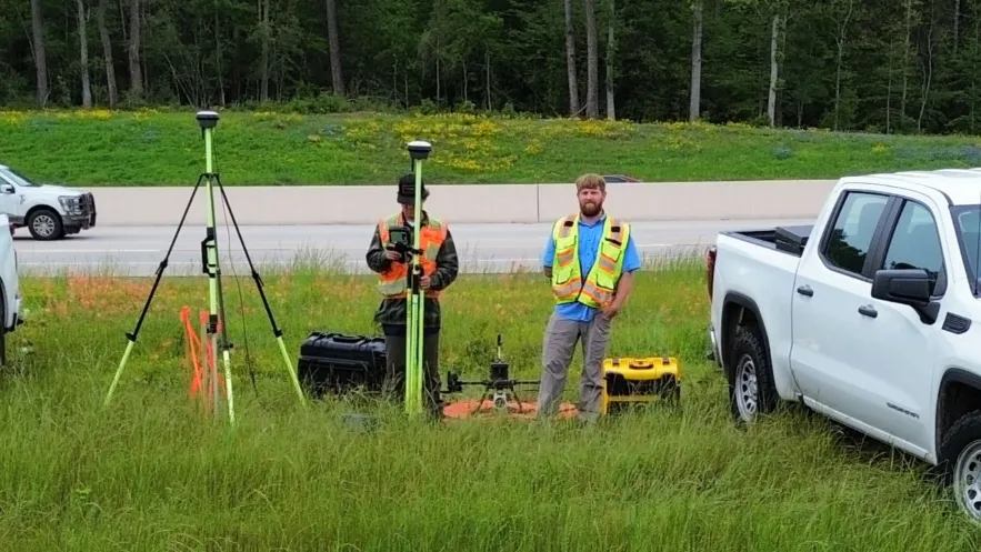
Modern technology plays a crucial role in the efficient surveying of large areas:
GPS Technology GPS (Global Positioning System) surveying is particularly effective for large-scale land surveys. It provides highly accurate data and significantly speeds up the process by using satellites to pinpoint exact locations on the earth's surface.
Drone Surveys Drones offer a quick and cost-effective method to capture comprehensive aerial images and topographical data of extensive properties. They are particularly useful in accessing difficult terrains and providing real-time data for large land areas.
GIS Mapping Geographic Information Systems (GIS) are used to create detailed maps and gather, manage, and analyze spatial data. This technology is essential for large land surveys as it helps in organizing and visualizing geographical data effectively.
Field Work
Field work for large properties is conducted with a team of experienced surveyors. Using the right mix of technology and traditional surveying methods, the team covers the property systematically. This process is supported by mobile mapping systems and electronic field notebooks to record data accurately on-site.
Data Processing and Analysis
Once the field data is collected, it undergoes processing and analysis. Using specialized software, the data is compiled into usable formats such as digital maps and plots. This step is crucial for ensuring the accuracy of the survey and providing actionable insights for property management or development.
Continuous Monitoring and Updating
For very large properties, continuous monitoring might be necessary to account for changes over time due to natural causes or human activities. Regular updates to the survey data help in maintaining its relevance and accuracy for ongoing or future use.
Surveying large properties requires a combination of detailed planning, advanced technology, and skilled fieldwork. At South Texas Surveying, we are equipped with the expertise and technology to handle large-scale surveys efficiently and accurately. Our commitment to quality and precision makes us a trusted partner for any land surveying needs.
