Surveying Texas Since 1980 Family Owned, Customer Devoted | Firm #10045400 | 281-556-6918

Thank You!
Thank you for requesting a bid! We'll have a team member call you soon to discuss your needs.
Delivering Land Surveys with Attention to Detail
George Owens

I have worked with many surveying companies, but South Texas Surveying stands out for their exceptional professionalism, attention to detail, and commitment to their clients.
Kim Wexler
Their accurate and thorough surveys make my job a lot easier, their ability to communicate effectively with all parties involved is commendable. I highly recommend South Texas Surveying.
James Cart
As a new homeowner, I was thoroughly impressed with the professional service provided by South Texas Surveying. I high recommend their services to any one buying a home in Houston.
Read Our Latest Blog
What is an Aerial Survey? Exploring Advanced Land Mapping Techniques
“South Texas Surveying leverages the power of aerial land surveys to provide clients with accurate, efficient, and comprehensive surveying solutions.” - Christopher Evans
Understanding Aerial Land Surveys
Introduction to Aerial Land Surveys
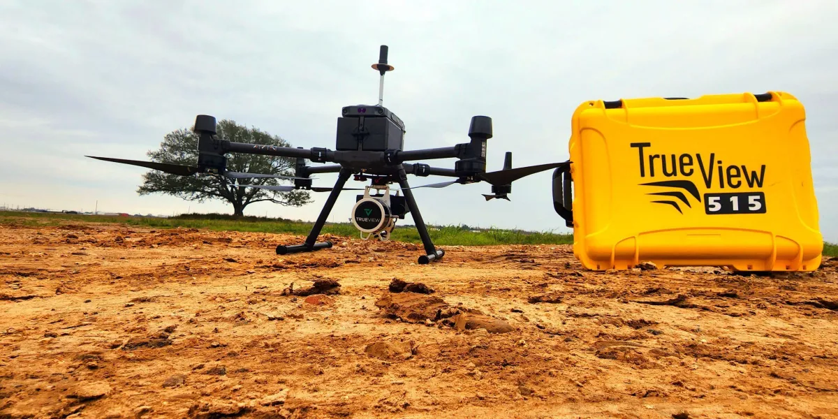
Aerial land surveys represent a cutting-edge method of collecting geospatial information by using aircraft or drones equipped with cameras, sensors, and other remote sensing technology. This approach allows surveyors to capture detailed images and data of large tracts of land quickly and accurately. Aerial surveys are invaluable for mapping, planning, and managing land resources, offering a bird’s-eye view that ground-based surveys cannot match.
Advantages of Aerial Surveys
The primary advantage of aerial land surveys is their ability to cover extensive areas efficiently, reducing the time and labor costs associated with traditional survey methods. They provide a comprehensive perspective of the land, revealing natural features, infrastructure, and any changes in the landscape. This efficiency and comprehensive coverage make aerial surveys particularly useful for large-scale projects, environmental studies, and urban planning.
Technologies Used in Aerial Surveys
Aerial land surveys utilize advanced technologies, including photogrammetry, LiDAR (Light Detection and Ranging), and infrared imaging. Photogrammetry involves stitching together aerial photographs to create detailed 3D models of the surveyed area. LiDAR technology uses laser pulses to generate precise topographical maps, while infrared imaging can reveal details not visible to the naked eye, such as heat signatures and water sources.
Applications and Uses
Aerial surveys have diverse applications across various sectors. In agriculture, they assist in crop monitoring and management, while in construction, they support site planning and design. Environmental scientists use aerial surveys for ecosystem monitoring and natural resource management. Additionally, these surveys play a crucial role in disaster management, allowing for rapid assessment of affected areas post-disaster.
Challenges and Considerations
While aerial land surveys offer numerous benefits, they also present challenges, such as weather dependency, airspace regulations, and data privacy concerns. Surveyors must navigate these challenges carefully to ensure successful and compliant survey operations. Advanced planning, understanding regulatory constraints, and employing appropriate technologies are essential for conducting effective aerial surveys.
South Texas Surveying and Aerial Surveys
South Texas Surveying leverages the power of aerial land surveys to provide clients with accurate, efficient, and comprehensive surveying solutions. By embracing advanced technologies and methodologies, South Texas Surveying ensures that clients receive top-notch service that meets their specific needs, whether for real estate development, agricultural planning, or environmental analysis. Their expertise in aerial land surveys translates into high-quality data and insights, driving informed decision-making and successful project outcomes.

Contact Us
Email: [email protected]
Office Address: 11281 Richmond Ave
BLDG J, Suite 101,
Houston, TX 77082
Office Hours: Mon – Fri 8:00am – 5:00pm
Office Phone Number: 281-556-6918
11281 Richmond Ave
BLDG J, Suite 101,
Houston, TX 77082
Firm Number: 10045400
Resources
© Copyright 2024 South Texas Surveying Associates